Friday, August 5, 2011

Uluru and the Olgas

Uluru and the Olgas


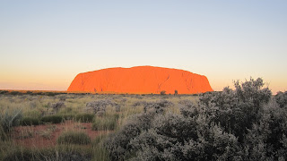
We arrived at Yularu, the camping ground and resort about 8 kms from the Uluru in time to take to see the Rock at sunset.  The view was spectacular, as the Rock changed colours with the setting sun.  The Rock is in a national park with different, specific areas for viewing the Rock at both sunset and sunrise.  We were surprised at how popular each of these were.  It was pretty cold on both occasions but well worth donning on the winter wollies for.

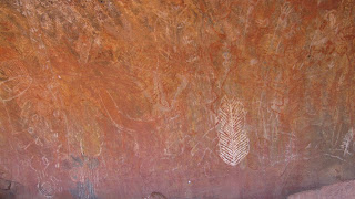
We then went on the Mala walk at the Rock.  This involved a member of the Anangu aboriginal clan showing us what are the sacred areas of the Rock to his people.  We saw the specific men, women and old people’s areas and the rock drawings were explained. 


 We then walked around the Rock which took about 3.5 hours.  The changing face of the Rock was highlighted and there were also many beautiful flowers although we did not see any animals which surprised us.  After gaining an understanding of the real significance of the Rock to the Anangu people we elected not to climb the Rock although we think we were in the minority.


All in all we walked 12 interesting kms so a good day was had.
The next day we went to the Olgas which are accessible via the Rock. The Olgas are different from the Rock although made up of the same rock types.  We started with the full Valley of the Winds walk which was breathtaking in more ways than one. 


The scenery was wonderful, especially as the rains earlier this year has left everything very green.  The walk was 7.4 kms up hill and down dale and scampering over rocks but once again was worth it.  We decided our fitness could handle one more walk so we went on the Walpa Gorge walk which was only 2.6 kms.  It was pretty and we saw  some lovely small water pools.  Overall we had walked about 20 kms over the 2 days but it was certainly worth it, and I was still able to move the next day.


Thursday, August 4, 2011

Queensland/NT Border to Alice Springs


We continued on the dulating Barkly Highway to Barkly Homestead.  We were now used to roadhouses, normally a working station with a caravan park of sorts, petrol and a small shop.  Barkly homestead was one of the best we had seen with a good bar.
Sunset at Barkly Homestead

After a god night sleep at the homestead we continued west until we hit the Stuart Highway at Three Ways.  We then went south to Tennant Creek.  We had been told that Tennant Creek was the Soweto of the Territory and it certainly did not sell itself well.  Most shops had bars and /or shutters on the windows and there were a lot of people that seemed to be sitting around doing very little.  Marty asked the nice old lady in one of the shops how long she had be in the town and where she had come from.  When she said she had come from the Barossa Valley he asked why did she move to the Creek.  She replied”cos
 if was f###ing cold”.  It was quite a surprise to have a sweet old lady of about 70 come out with that word and it was not the only time she used it. 
We were entertained in our camping ground by a bush storyteller who brought along a few samples of bush tucker.  We ate most things but I baulked at the witchery grubs but Marty ate them as well.
Jimmy the Bush Story teller


Jimmy and his Bush Tucker

We left the next day for Wycliffe Well the self-proclaimed UFO Capital of the Territory.  We lunched at the magnificent Devils Marbles en route.  It was amazing to see these large, round boulders suddenly appear on the side of the road and then disappear only a few ks later.  We had a good time walking around and over them.  We saw the giant steel sculpture of an Anmatjere man on hill overlooking Aileron and the equally large woman and child in the town.  Every town has to have a hook. 


At the Alice we stayed with my friend Elaine (Curls) from school, her husband Alan (Frapper) and their rotund miniature daschunds.  We went to the Alice Springs markets which for Canberraites is not dissimilar to the Hall markets.  We then went to the Museum of Pioneer Women in the old gaol which was very interesting although Marty couldn’t see any reason why we should commemorate any women at all
Frapper & Curls in Alice Springs


Wednesday, August 3, 2011

the last of Queensland


After saying goodbye to new friends Col and Jen from Kurri Kurri,

 we travelled west along the Barkly Highway from Cloncurry to Mt Isa as we prepared to exit Queensland.  On the way we called in at the ruins of the town of Mary Kathleen, halfway between Cloncurry and ‘the Isa’.  It was a major disappointment as there is very little of the town left.

In Mt Isa we went on the Hard Times Mine Tour.  This involved going down a mine in the middle of the town, created by miners to illustrate what a contemporary working mine and an older mine is like.  We donned miner’s wellies, bright orange overalls and hard hats and stayed underground for two hours.  We are now quite sure, even if we weren’t before, that we do not want to be miners, even given the pay rates that were quoted to us.  The tour was good as we got to play with a variety of machinery and gain an understanding of what goes on in a mine.  Marty was in top form and let me know that he couldn’t find a matching pair of boots and had to wear one size 8 regular (right) and one size 8 large (left)!!.  


We also got an understanding of Mt Isa by going up the town’s lookout.


The caravan park where we stayed put on a singer (Just Helen) as entertainment each night.  She song both types of music (country and western) and whilst Marty was watching the footy in the pub I bought 3 CDs to listen in the car.
Finally after entering Queensland on 17 April we exited on 19 July after travelling a further 202 km to the border via Camooweal.
What shall we miss about Queensland?
                The word ‘eh’ added on to the end of sentences
                All the Victorians on the road.


Sunday, July 24, 2011

Sshhh we can’t tell you


We travelled from Mt Surprise and set up camp in our new location. While settling down for a relaxing afternoon, we were greeted by another camper who informed us that we had set up in the happy hour spot and that at 4.30 everyone else in the camping ground would be gathering around for the daily ritual. Our response was that we were happy with the daily gathering just as long as we were able to join them. And true to her word at 4.30 the chairs started to appear, so we did join in.
Our reason for venturing out here is to visit Cobbold Gorge, unlike our fellow campers who are all here looking for gold. It wasn't long before some of them were willing to show us exactly what they are looking for. One gentleman showed us a tiny little yellow coloured rock and told us that it was gold. It did not look like gold to me, but others produced all sorts of containers such as medical specimen jars that held some of the spoils from days, weeks of scouring the ground at their secret spot.
These modern day gold prospectors know each other well as they have all been coming here for years. They are using metal detectors or copper rods but really they are just looking for the bigger nuggets. But no one tells anyone else exactly where their secret spot is. One bloke told us that he had come up here each year for 7 years without finding a thing and then found 18 ounces of gold (about $23k) in a few days but he couldn't tell us where he found it. Every prospector is trying to find out from his mate where the secret spot is and everyone is very friendly until you ask that question "where do you go looking for gold"? It is a fascinating sub-culture. It is sort of like the fishing guys who can show you what they caught but can't tell you where they caught it.
The metal detectors also find lots of other things out there in the wilderness, the prospectors are searching on some of the country's large outback cattle stations and some of the other things that are found are the metal spurs from the cowboys boots or the old metal heel protectors, old tobacco and matches tin dating back to the 1800's.

Sunday, July 17, 2011

Townsville to Cloncurry via Normanton


After the wedding we left Townsville for Mount Surprise and the Undara volcanic National Park
Mt Surprise – here we explored another fascinating geological wonder the Undara Volcanic National Park, the cooling molten lava of an erupted volcanic flow of lava 190,000 years ago forming 90km of hollow underground lava tube from a single volcano. The lava quickly cooled and crusted, while the interior lava drained beneath to leave long, dark, hollow tubes at a length of over 160km. We also walked the eggcup-shaped crater on the 2.5 km Kalkani crater circuit. The guide took the time to explain the science first before taking us below ground to the lava tubes. This was a great approach as it allowed us to understand what we were seeing.


Kalkani crater


Next we went to Forsayth, an old mining town which is one of the few remaining towns of a large number which existed on the Etheridge Gold Fields. For anyone who wants to try their luck detecting there is still some gold and relics out there.

We went on a guided boat tour through the rugged sandstone formations of Cobbold Gorge. This gorge is very narrow, closing to 2 metres wide in places with 30 metre high cliffs on both side, and some the native wildlife that we got to see included freshwater crocodiles, heron and many different fish. Again we walked to the top of the gorge first before descending to the bottom of the gorge so we could understand what we were about to see on the boat.


Back onto the Gulf Development Road at Georgetown we stopped at Croydon for a picnic lunch in the park and that we looked through the Croydon general store which has been trading since 1894.Then on to our next camp at Normanton.

Normanton is a historic town at the centre of the Gulf Savannah grassland. Here we spent the day doing a self guided walking tour of the town that included the original artesian bore that supplies "hot" water to the amenities in the caravan that we stayed in.


Artesian Bore, Town well/ Light pole


With crocodiles prevalent here we saw a replica of the largest one ever shot in 1957 measuring 8.63m.


Krys the Croc - the Savannah King
 Our walking tour finished at the Railway Station, museum and home of the famous Gulflander Train, just in time to catch at short train ride on this historic 140 km rail line but we only went out to Critters Camp and return. It was interesting as the camp is a transhipment point in the wet season where road trains load their cargo onto barges. It is the only guaranteed way that the town can be resupplied in the wet.


Gulflander Train

Before we packed up to leave Normanton we out took our breakfast out to Burke & Wills –camp 119, it is the most northerly camp site of the Burke and Wills expedition party crossing inland.


Burke & Wills Camp 119


Whilst in Normanton we heard of the fantastic sunsets at Karumba so we decided to have dinner at the pub on the beach at Karumba Point. The locally caught barramundi was great and the sunset didn't let us down and they were at least 30 or 40 people ready to capture it on film.

Karumba Point sunset


We then travelled south about 400 kms to Cloncurry. We visited the Mary Kathleen Museum which told the story of the abandoned mining town and the Rev John Flynn Museum which provided information on the founding of the Royal Flying Doctor Service.


The next day we went to McKinlay and the Walkabout Creek Pub, home of the Crocodile Dundee films.


We continued south to Kynuna and the Blue Heeler pub, the location of the first public recital of Waltzing Matilda. It is an amazing pub and even has its own surf life club and boat even though it is over 1,000 kms from the ocean.


Blue Heeler Hotel famous hotel with illiminated blue heeler statue on the roof.  Waltzing Matilda Exhibition

We finished the day by a trip to the billabong that is generally accepted to be the setting for Waltzing Matildas. It is about 23 kms from Kynuna and is incredibly peaceful.

Combo Waterhole Conservation Park the events described in "WaltzingMatilda" occurred in this conservation park.