Friday, August 5, 2011

Uluru and the Olgas

Uluru and the Olgas


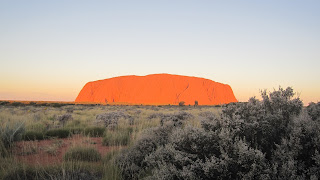
We arrived at Yularu, the camping ground and resort about 8 kms from the Uluru in time to take to see the Rock at sunset.  The view was spectacular, as the Rock changed colours with the setting sun.  The Rock is in a national park with different, specific areas for viewing the Rock at both sunset and sunrise.  We were surprised at how popular each of these were.  It was pretty cold on both occasions but well worth donning on the winter wollies for.

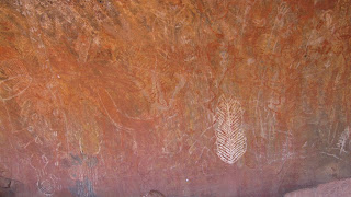
We then went on the Mala walk at the Rock.  This involved a member of the Anangu aboriginal clan showing us what are the sacred areas of the Rock to his people.  We saw the specific men, women and old people’s areas and the rock drawings were explained. 


 We then walked around the Rock which took about 3.5 hours.  The changing face of the Rock was highlighted and there were also many beautiful flowers although we did not see any animals which surprised us.  After gaining an understanding of the real significance of the Rock to the Anangu people we elected not to climb the Rock although we think we were in the minority.


All in all we walked 12 interesting kms so a good day was had.
The next day we went to the Olgas which are accessible via the Rock. The Olgas are different from the Rock although made up of the same rock types.  We started with the full Valley of the Winds walk which was breathtaking in more ways than one. 


The scenery was wonderful, especially as the rains earlier this year has left everything very green.  The walk was 7.4 kms up hill and down dale and scampering over rocks but once again was worth it.  We decided our fitness could handle one more walk so we went on the Walpa Gorge walk which was only 2.6 kms.  It was pretty and we saw  some lovely small water pools.  Overall we had walked about 20 kms over the 2 days but it was certainly worth it, and I was still able to move the next day.



Thursday, August 4, 2011

Queensland/NT Border to Alice Springs


We continued on the dulating Barkly Highway to Barkly Homestead.  We were now used to roadhouses, normally a working station with a caravan park of sorts, petrol and a small shop.  Barkly homestead was one of the best we had seen with a good bar.
Sunset at Barkly Homestead

After a god night sleep at the homestead we continued west until we hit the Stuart Highway at Three Ways.  We then went south to Tennant Creek.  We had been told that Tennant Creek was the Soweto of the Territory and it certainly did not sell itself well.  Most shops had bars and /or shutters on the windows and there were a lot of people that seemed to be sitting around doing very little.  Marty asked the nice old lady in one of the shops how long she had be in the town and where she had come from.  When she said she had come from the Barossa Valley he asked why did she move to the Creek.  She replied”cos
 if was f###ing cold”.  It was quite a surprise to have a sweet old lady of about 70 come out with that word and it was not the only time she used it. 
We were entertained in our camping ground by a bush storyteller who brought along a few samples of bush tucker.  We ate most things but I baulked at the witchery grubs but Marty ate them as well.
Jimmy the Bush Story teller


Jimmy and his Bush Tucker

We left the next day for Wycliffe Well the self-proclaimed UFO Capital of the Territory.  We lunched at the magnificent Devils Marbles en route.  It was amazing to see these large, round boulders suddenly appear on the side of the road and then disappear only a few ks later.  We had a good time walking around and over them.  We saw the giant steel sculpture of an Anmatjere man on hill overlooking Aileron and the equally large woman and child in the town.  Every town has to have a hook. 


At the Alice we stayed with my friend Elaine (Curls) from school, her husband Alan (Frapper) and their rotund miniature daschunds.  We went to the Alice Springs markets which for Canberraites is not dissimilar to the Hall markets.  We then went to the Museum of Pioneer Women in the old gaol which was very interesting although Marty couldn’t see any reason why we should commemorate any women at all
Frapper & Curls in Alice Springs


Wednesday, August 3, 2011

the last of Queensland


After saying goodbye to new friends Col and Jen from Kurri Kurri,

 we travelled west along the Barkly Highway from Cloncurry to Mt Isa as we prepared to exit Queensland.  On the way we called in at the ruins of the town of Mary Kathleen, halfway between Cloncurry and ‘the Isa’.  It was a major disappointment as there is very little of the town left.

In Mt Isa we went on the Hard Times Mine Tour.  This involved going down a mine in the middle of the town, created by miners to illustrate what a contemporary working mine and an older mine is like.  We donned miner’s wellies, bright orange overalls and hard hats and stayed underground for two hours.  We are now quite sure, even if we weren’t before, that we do not want to be miners, even given the pay rates that were quoted to us.  The tour was good as we got to play with a variety of machinery and gain an understanding of what goes on in a mine.  Marty was in top form and let me know that he couldn’t find a matching pair of boots and had to wear one size 8 regular (right) and one size 8 large (left)!!.  


We also got an understanding of Mt Isa by going up the town’s lookout.


The caravan park where we stayed put on a singer (Just Helen) as entertainment each night.  She song both types of music (country and western) and whilst Marty was watching the footy in the pub I bought 3 CDs to listen in the car.
Finally after entering Queensland on 17 April we exited on 19 July after travelling a further 202 km to the border via Camooweal.
What shall we miss about Queensland?
                The word ‘eh’ added on to the end of sentences
                All the Victorians on the road.